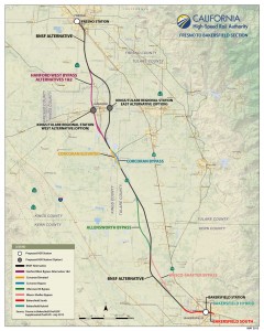
The California High-Speed Rail Authority and the Federal Railroad Administration (FRA) have announced the availability of the Final Environmental Impact Report/Environmental Impact Statement for the Fresno-to-Bakersfield project section of the California High-Speed Rail project. The Final EIR/EIS represents a comprehensive, project-level review of the section that runs approximately 114 miles from downtown Fresno to downtown Bakersfield, with proposed stations in the Kings-Tulare County region and Bakersfield to go with a Fresno station location approved in 2012.

The Final EIR/EIS identifies the preferred alternative as parts of the Burlington Northern Santa Fe alternative (BNSF), the Corcoran Bypass alternative, the Allensworth Bypass alternative and the Bakersfield Hybrid alternative. Proposed stations include the east of Hanford/west of Visalia station option located near State Route 198.
The Kings/Tulare Regional Station is one of the few stations in the California HSR System not proposed in a downtown urban area. The two alternative sites for this station were selected to serve residents in the Lemoore/Hanford, Visalia and Tulare areas. The Kings/Tulare Regional Station–East Alternative is immediately east of the city of Hanford‘s primary sphere of influence and is adjacent to the intersection of SR 198 and SR 43 on the BNSF Alternative Alignment. These two highways would provide access to the station for shuttle bus service from the communities in the area.
The Kings/Tulare Regional Station–West Alternative is situated between the city of Hanford and the unincorporated community of Armona on the Hanford West Bypass 1 and 2 alternatives and Hanford West Bypass 1 and 2 Modified alternatives. SR 198 would provide access to the station for shuttle bus service from the communities in the region.
The proposed Hanford West Bypass 1 and 2 alternatives diverge from the BNSF Alternative at approximately East Conejo Avenue; both alternatives pass the city of Hanford to the west and rejoin the BNSF Alternative at SR 43 north of the city of Corcoran. The alternatives are on the same alignment from north to south until about Jackson Avenue, where the Hanford West Bypass 1 Alternative curves farther to the west to join with the BNSF Alternative north of the city of Corcoran. The Hanford West Bypass 2 Alternative remains on a more southeasterly route to join with either the Corcoran Elevated Alternative or the Corcoran Bypass Alternative.
The Corcoran Elevated Alternative would be the same as the corresponding segment of the BNSF Alternative except that it would pass through the city of Corcoran on the eastern side of the BNSF Railway right-of-way on an elevated structure. The Corcoran Bypass Alternative would diverge from the BNSF Alternative at approximately Nevada Avenue and swing east of Corcoran, rejoining the BNSF Alternative at Avenue 136 south of Corcoran.
The Allensworth Bypass Alternative would diverge from the BNSF Alternative at Avenue 84 in Tulare County and swing west of Allensworth State Historic Park, rejoining the BNSF Alternative at Elmo Highway in Kern County.
On May 6 and May 7, the Authority’s board of directors will host a two-day meeting at Fresno City Hall to take public comment and consider certification of the Final EIR/EIS and approval of all or parts of the Fresno to Bakersfield section of the project. The May 6th meeting, scheduled 3-7:30pm, will include staff presentation of the report and allow for public comment on the Final EIR/EIS. The board will deliberate and possibly act on the report at the 10am meeting on May 7.
Following any action by the board, the FRA will consider approving the Fresno-to-Bakersfield project section and issuing a Record of Decision related to the project and the Final EIR/EIS. That action is anticipated to occur in May or June.
The Final EIR/EIS and associated documents have been posted on the Authority’s website at www.hsr.ca.gov/Programs/Environmental_Planning/final_fresno_bakersfield.html and on the FRA website at www.fra.dot.gov.
